System map (Photo credit: Wikipedia)
Kerry and Kira must return home this morning. I still have time off, so after coffee and warm goodbyes, I wander off towards Victor and Cripple Creek.
There is nothing I really need to see or do in either location, but both are visually interesting, old mining towns with that seedy charm so typical of western boom and bust towns. Old, sagging, abandoned homes litter the outlying parts of the towns, while red brick buildings line the main street. I drive by mine entrances, rusty mounds of tailings and scarred mountainsides. It’s the ugly side of Colorado. Equally appalling are the mines, tailings, and polluted ponds between Leadville and I-70 in Central Colorado. If you have not seen this area, imagine driving through beautiful mountain country over high passes. Imagine creeks, beaver dams, aspens, and tall firs. Then, imagine coming around a corner and seeing a horrific scarred, mining landscape in all directions. It is a shock to the senses and to me even feels evil as I drive through. It takes nearly a half hour of driving to get out of the darkness and back into the enchanted forests.
Finally after a few more harrowing stretches of mountain roads, I arrive in Victor and stop at the visitor center. They are oddly out of maps and do not offer coffee, the only reasons I ever stop at a Visitor Center but here I strike out. The Visitor Center lady informs me that there is no place for breakfast either, so I head out of town towards Cripple Creek.
In Cripple Creek, which is now a casino town, I drive through the center of town slowly. Cripple Creek is easy to find on the other, paved roads from Colorado Springs so I have been here many times before. It is a favorite spot for viewing golden Aspen trees in the fall. I keep traveling today, now towards the main road that will go to Colorado Springs and eventually to I-25, the perennial road home.

Cripple Creek, 1957 (Photo credit: Wikipedia)
But first, I plan to set up camp before I head home tomorrow. I know of several areas through here where I have camped or hiked in the past. I decide that I will check out whatever shows up first. I am pleased when I see the small sign to Crags Campground (National Forest), which is up a dirt road on the backside of Pikes Peak. Years ago, I drove up this steep winding road (in my former mountain pass tizzy) to hike part way up to the Pikes Peak summit trail. I remember there are dispersed sites as well as an established campground. When I see that the dispersed sites are empty on this Monday morning, there is no need to look any further. I pull into to a heavily-shaded spot next to a small creek. The water flows freely, making a peaceful sound in the background. It’s a picture-perfect little mountain site and it is free. I straighten up the van, finally eat something, then place my chair near the creek where I read, write, and solve Sudoku puzzles. I rarely admit that after all these years, I still do the “easy” puzzles. I can do medium but I don’t want to spend that much time on Sudoku. I do several easy ones then on to something else.
It is also time to check my satellite radio for any royal baby news. Bingo! Finally the Duchess is in labor. Oh happy day. It’s about time she pops. I check back hours later and learn that she has delivered a healthy baby boy. I hear the cheering crowds outside Buckingham Palace and send up some prayers for good health and much joy. Babies have a way of bringing hope into the world.

Poison-Oak (Photo credit: Wikipedia)
Tango and I get restless and decide to explore the creek. I notice that the sides are lined with poison oak! Yikes! Can dogs get poison oak? I don’t have any idea, and without Internet service I cannot find the answer. I keep Tango on a leash which he does not enjoy. We navigate back and forth across the creek, hopefully avoiding the poison oak. I look to my right and see the rock outcroppings that I believe provide the perfect black bear den. If you are so inclined, you can scramble up the two story rock ledges but at this time of year I imagine I would interrupt bears and snakes. Right on cue, Tango raises his nose and sniffs frantically into the wind. I stopped hiking alone in Colorado many years ago because of these imagined bear hotels and I quickly retreat now. I stick to the area near the van and remind myself to pack up dog food and other tidbits before retiring for the night.
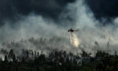
It is going to be a cold night. I can tell from the chilly air around me in the afternoon that when the narrow sliver of light leaves this little canyon, I will be bundling up. I did not bring firewood because for a while Colorado was on a fire ban. I am not far from several devastating burn areas, including the land scorched by the Haman (2003) and Waldo Canyon (2012) fires so I don’t worry too much about missing a campfire for one night. Instead, I will snuggle up in the van and read more. I finish Bird Cloud, by Annie Proulx this morning and will start The Longest Road by Phil Caputo tonight. Bird Cloud is a memoir by Proulx that documents her experiences building a house and living in in Wyoming, not far from where I live. The Longest Road is the account of Caputo’s recent travels from Key West to the Arctic Ocean in a camper. I can read that kind of stuff forever, or tonight, until my Kindle runs out of power.
I hear a jarring roll of thunder, which is typical in the Colorado high country in the late afternoon. Peak baggers know to be off the trails by then. I hope we don’t get a downpour though. It is so peaceful sitting outside next to the creek.
Tango and I wake up early and head out around 8 AM. I am looking forward to stopping at the Starbucks in the small city of Woodland Park. Fresh coffee! Yogurt! Internet service! I can’t wait to post the first installment from this trip. The temps are cool enough to leave Tango in the van and I wander into civilization and order a Java Chip Frappuccino Light and a cold yogurt—everything that I hopped it would be.
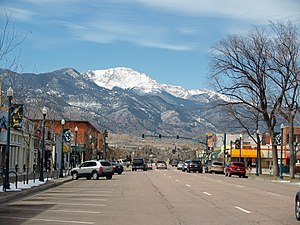
Back in the van I head out of the mountains towards Colorado Springs. I still have my condominium near Cheyenne Mountain, but it has been rented for 7 years now and a company manages it for me. I had planned to retire back to Colorado Springs someday but, after living in a small town, it is hard to imagine anything different. So, it will stay a rental for the time being.
As I wander down HWY 24, I enter the Waldo Canyon burn area. I am sad to see the burnt matchstick trees on the hillsides. After living in Colorado for about a month, I took my first local hike up Waldo Canyon. Sad.
I know that I will pass right by an RV dealer and decide to stop and see what they have. I end up making an offer on a used Chalet A-frame pop up camper. I love it so much but the guy would not budge on the price, which according to my bank was $3000 over the NADA value. I could pay the difference, but don’t want an overpriced 2005 camper. As I drive north on I-25 I ponder the situation about what I should buy. I have vacillated so many times—Class C, travel trailer, and so on, not able to make up my mind. The main frustration is that everything in my price range is trashed and claustrophobic. My wants are bigger than my budget. I really want something new that has a warranty and is properly priced. Later, I stop at another RV dealer south of Fort Collins, and score big!!!

U.S. Air Force Academy Waldo Canyon Fire (Photo credit: Official U.S. Air Force)

Waldo Canyon Partnership-a (Photo credit: USDAgov)

Downtown Colorado Springs, Colorado. (Photo credit: Wikipedia)
Related articles
- Colorado Camping Trip (janesjournals.wordpress.com)
- Colorado Camping Trip 2: Stuck in the Mud (janesjournals.wordpress.com)
- Pike’s Peak or Bust! (culdesaccool.com)
- Rain through Ute Pass makes some drivers nervous (krdo.com)
- Flash Flooding Causes Big Damage In Waldo Canyon Burn Area (denver.cbslocal.com)
- Waldo Canyon fire: A year later, life returning to normal (denverpost.com)
- Colorado Springs poised to upgrade Pikes Peak summit house after years of neglect (denverpost.com)
Thanks….more big news tomorrow about a camper purchase!
Thanks! I just posted the news
lucky you getting the pass. I have a few more years before I can get mine….never have looked forward to getting older, but the Parks Pass makes it all ok!