Whenever I see huge cargo ships, as I do often up here, I wonder where they came from, what is on them, and where the stuff goes after it arrives at an American port. I am also fascinated by how many ships come into a port and how many are traveling on the open ocean at any given moment.
I now have a lot of answers after downloading a marine traffic app. Thanks to the app, I can see every boat coming and going across the sea and into harbors, anywhere in the world (container ships, oil tankers, tugs, yachts, sailboats, ferries, fishing boats). It is fascinating. Have you ever seen maps showing how many planes are in the air? Marine traffic apps show the same heavy traffic. It is truly amazing.
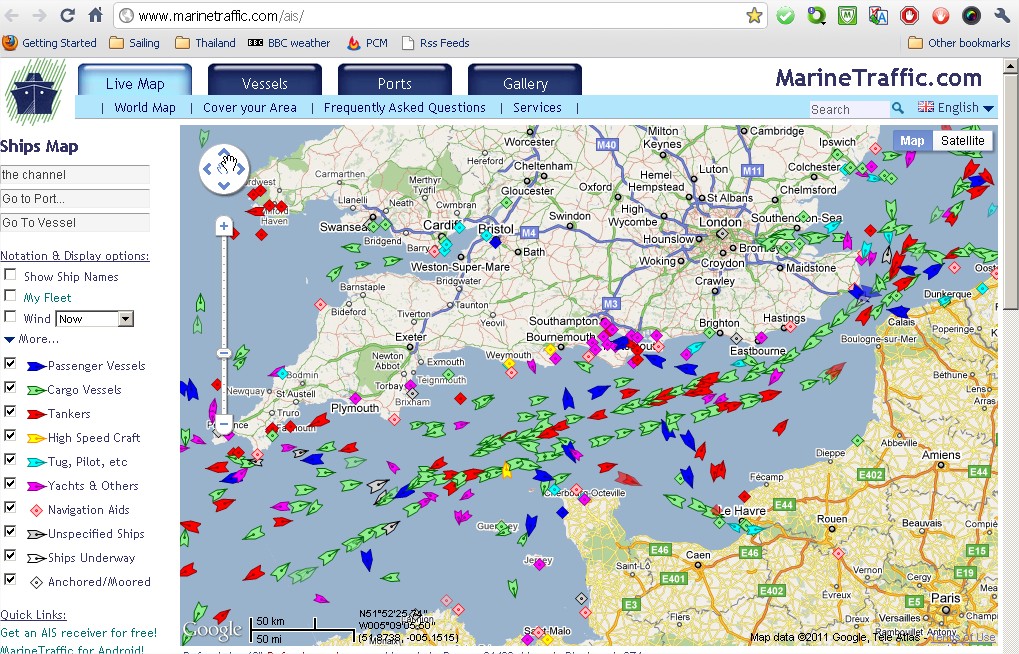
Below is a screenshot (English Channel?) in the app that I use, but I found this image online. On the map, If the ship is moving, it looks like the pointed tip of a pen. If it is stopped, it is a small square. You can see what all the colors mean to the lower left. I have been especially interested in the green cargo ships. On this map, you can see a steady flow of cargo ships in and out of the channel. I am also curious about the red tankers and their movement.
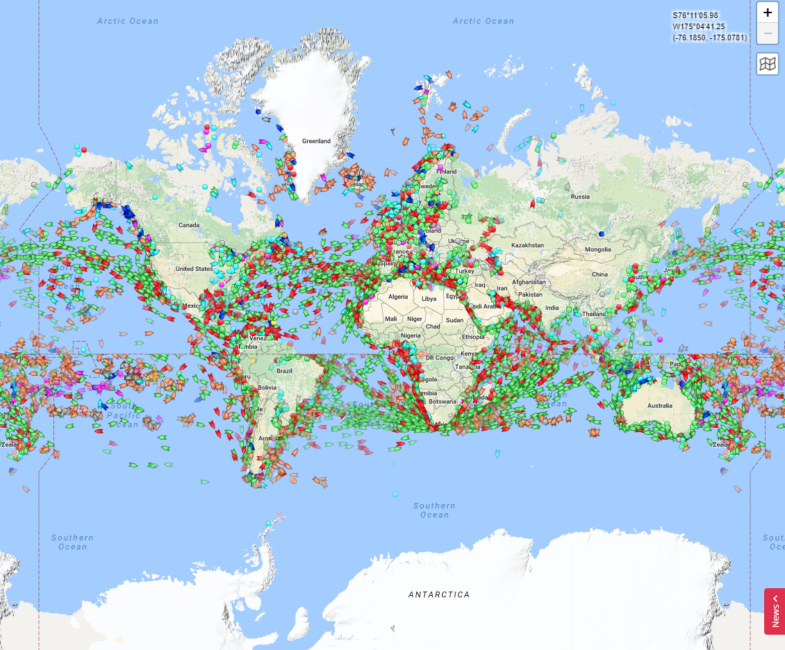
The following, also something I found on a Google search, shows ships in the water all over the world. I love seeing the actual shipping lanes across the oceans. You can also see just how many ships have to go around the tip of Africa and the bottleneck around the Panama Canal.
The following shows ships in the Indian Ocean and Western Pacific. Again, shipping lanes for cargo ships are easily identified. So many pink yachts/sailing vessels out there as well. Who owns all those?!

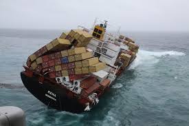
Sometimes, in bad weather, shipping containers slide off! Yikes. Looks like they are sliding off from the front and back.
Last night using the app on my phone, I monitored several container ships on the Strait of Juan de Fuca as they passed north of Sequim. If I click on the pointy boat icon I can see its name, size, the owner, what flag it flies under, where it came from, and where it is going. No surprise that my cargo ships were coming from China and Japan. However, one had already made a stop, in Vancouver, before heading to the Port of Seattle. Some of these ships are gigantic, and you can read about them here and here. I also located the container cargo ship that I had seen while kayaking on Saturday morning. It was safely in port, probably being offloaded.
Ever wondered about the popularity of shipping containers? I discovered it is a fascinating story, which you can read about here. A sweater costs 2.5 cents to ship across the sea from Asia! Ninety percent of the parts for any given item came across in a container!
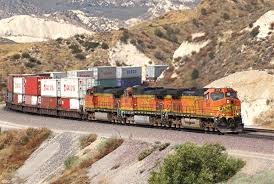
So, what about the movement of the shipping containers after reaching a port? I just bought a $10 pair of shoes from Walmart to slip into when I need to take Tango on a short walk near the RV park. I tried to imagine the shoe’s journey to me in a container that originated in China. Once in a US port, containers go by train to a point near a giant warehouse. Trucks move the containers to the warehouse and they are offloaded. From there, goods are moved to distribution centers by truck, as shown in the following:
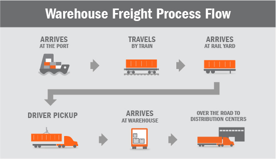
As I travel the country, I often see mile-long trains transporting containers, sometimes stacked two-deep. They are going to regional warehouses for companies like Walmart.
I learned that Walmart has different centers and networks for clothes, perishable items, tires, drugs, etc. In this case, if my shoes came into Seattle, Portland, or LA, the closest clothing distribution center would be in Utah. If you go to this website and scroll down, you can find maps showing all the main distribution centers for Walmart. So, my shoes traveled from a port to a warehouse, to a distribution center. From there, it arrived at my store in Sequim via another truck. I see Walmart trucks on the highways all the time when I travel. So much movement of so many goods. My shoes traveled more than I did this past year!
Transportation makes the global economy flourish. So many people have jobs in this supply system to bring me my cheap shoes. But think of the energy it takes. Diesel fuel used by the ships, trucks, and trains emits black carbon, which is as polluting as carbon dioxide. However, carbon emissions are only one environmental issue. What about sea life? In Seattle, for example, port traffic has contributed to the reduced Orca populations. Only 74 resident Orcas live in Puget Sound and The Strait of Juan de Fuca now.
So, how are we going to balance the insatiable demand for goods with the need to mitigate climate change and the desire to stop killing off every creature on this earth? It seems the only hope is to stop our demand for the stuff. I learned in my basic college economics about the link between supply and demand. We have to stop the demand. I have to stop. I visited Walmart several times this week, and everything I purchased, except for food, came from one of those ships trudging across the Strait and damaging my local Orca population. I live simply and don’t consume much, but still, I contribute. The best thing that I can do, besides consuming less overall, is to renew my effort buy previously loved stuff. Most everything that I need is already out there somewhere, waiting for me to find it in a thrift store, at a yard sale, or online. But, everyone has to stop their demand.
I wish that shopping locally had a bigger impact. It feels good to support someone local, which I will continue to do, but really, it has little impact on the gigantic infrastructure that really runs the world. The movement of goods is a monstrous machine that involves every port, every manufacturing center, every consumer, every place on the planet. Just look at the maps above.
Is there any hope for a shipping and land-based transportation system that is less polluting? I am reading about that now and, in my initial readings, I see some hopeful developments. More on that later when I am better informed.
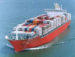
Anyway, so back to my marine traffic app. Despite the immense carbon pollution caused by the intertwined shipping, train, and trucking industries, I admit that it is fascinating to watch the ships move through this area in real time. On and off during the day, I have watched two incoming and two outgoing container ships in the Strait, north of me. I also monitored two oil tankers, one heading up to Alaska. The Port of Seattle has 4 container ships docked and one at anchor, the Diamantine. It is a bulk carrier that left Nagoya Japan 15 days ago. The ship was built in 2010 and the call sign is SVAX5. A tug named Olympic Scout nudged it into the harbor. I cannot tell what cargo it carries, which would be very cool to know, but I imagine that is proprietary information.
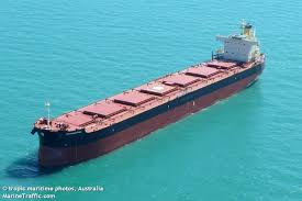
File photo from the Internet of the bulk carrier, Diamantina, which, earlier today, was nudged to the Port of Seattle by a tug and is now at anchor, probably awaiting a berth.


Wow, Jane, it’s frightening to see how many ships are out there, and to consider what they do to the environment! People are just now aware. Good for you for doing this research! I’ll post this on Twitter to help spread the word.
Thanks Diane! It is fascinating and scary
Yes, that’s the English Channe, the most densely packed waterway in the world; with the Straits of Dover providing an awkward pinchpoint. As you can see there are separate channels for each direction through the channel but also all the ferries going across it; and fishing fleets both sides.
For many years I made my living in shipping and international transport and started it all off at Newhaven on the Sussex coast. It was a fascinating industry to be in and I loved making visits to ports and docks specially if it meant a visit on a ship. One of the amazing things was the gentlemanly approach which existed then, in London the Baltic Exchange was the location for ship charters where deals were still sealed on a handshake. It was also one of the most beautiful buildings in the City of London but was sadly destroyed when the IRA bombed it.
I would be interested to know which App you are using.
Wow, that must have been quite interesting work! I had no idea that the English Channel was so densly packed but it makes sense, kind of a strategic position. I will send you the app name on FB to make sure you get it!