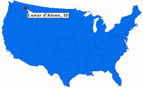
So happy that Coeur d’Alene has an abbreviation – CdA. I saw it first in a newspaper article. Apparently others decided that typing that lowercase d followed by an apostrophe is a bit cumbersome. So CdA it is.
CdA is a small city with 55,000 people, in the Idaho Panhandle. It is 15 miles from the Washington border, 100 miles from Canada and 65 miles from Montana.

See all the green stuff in the Idaho Panhandle? That is National Forest land. I am surrounded by lush forests, flowing rivers, and mountains, with minimal development.

Western Montana and Eastern Washington have even more national forest lands. The map below gives the best visual of my new regional “territory.” Green, green, green, meaning National Park lands.
A bit fuzzy, but the green areas are what I am showing.
What’s even more interesting: few people live in this area, compared to the Colorado Front Range. The summer temps rarely exceed 90 and winter temps do not dip below 10 degrees (compare with the same latitude on ND, which dips to minus 30 or minus 50). Shhhhhhh do not tell anyone. This area is pristine and undeveloped, much like, Colorado in the 60s-70s.
French fur trappers named the Native Americans in this area the Coeur d’Alene (Heart of an Awl). The heart of an awl in French is equal to pointed heart in English. This supposedly reflects their sharp trading skills. However, Lewis and Clark were the first Europeans to meet the Coeur d’Alene people. Of course, as the fur traders, military folks, and settlers moved in, their fate was the same as other Native Americans, and they now live on a few reservations in the area. The logging industry fueled the growth of CdA but the city is now a “destination” and relies on tourism.
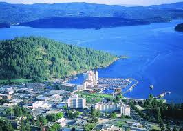 Downtown snuggles against the shores of Lake CdA. The area is vibrant, with shops, museums, parks and TRAILS!
A happy development: Kerry is flying up here from Denver next weekend to see his sweet bride for a few days. I should be able to get a hug or two as well!


