Yesterday I was rattled in a way that will forever affect my feeling of safety on our public lands. I was headed into the Chiricahua Mountains, a beautiful, remote, and rugged mountain range in Southeast Arizona that is about 65 miles north of the Mexico border.
That morning, I left my winter hangout in Deming, NM excited for two reasons. First, I was returning to a place I loved and backpacked while a student at the University of Arizona. At least 4 decades have passed since then, so I could not wait for a reunion with this stunning scenery. Second, I was planning to field test my new tent and screen house in preparation for a summer trip to Alaska. Tango and I would spend several days tent camping and hiking. I knew that the Monument campground would be full – they always are – so before leaving, I checked online and found a number of campgrounds in the Coronado National Forest, which is attached to the Chiricahua National Monument.
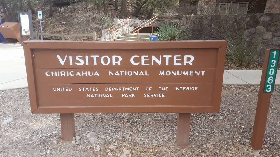 I drove the 140 miles filled with memories of my young adulthood and explored the Chiricahua National Monument as much as I could with a dog (only one trail there allows dogs). At the visitor center, I asked about camping in the area. Even though I had a general plan to camp on Forest Service Land, the staff usually has suggestions and maps, which makes finding a place easier.
Me: “Is there camping in the area?’
Visitor Center Staff (female): “There is some dispersed camping over the hill but the ground is soft up there. Here is a list of RV parks in the area.
As I scanned the RV list, I noticed that she kept pointing to an RV park in Sunsites, AZ, a fair distance from the mountains. She then left the front desk and asked a younger staff member to answer any further questions.
Me: “ I know there is camping in the National Forest as well. Do you have a map?
Staff person 2: “ Yes, here is a map”
Me: Are the Forest Service campgrounds open?
Staff person 2: “Sort of”
Me: What do you mean by sort of?
Staff person 2: They are open but no one is out there, no camp hosts, few other people
Me, feeling like we are talking in some kind of code: “Why didn’t the other lady want me to have a National Forest service campground map?
Staff person 2: “We don’t get any information about the National Forest camgrounds. They are separate from us. Here are their phone numbers. Call them, Here are two phone numbers. Call them for sure.
In 2017 I camped at least 90 days on National Forest Service lands .I have talked to dozens and dozens of public land employees, and I know their lingo. Red flags popped up all over the place during this conversation. Other National Monument staff gladly share information about camping on other units (National Monuments are administered by the National Park Service/Department of the Interior while National Forests are run by the National Forest Service/USDA). Furthermore, rangers and their kind do not say things like the ground is “soft”. They know and campers know that dispersed camping is in rugged, not manicured areas. And, if a problem exists, they don’t talk in code, like the “ground is soft”. Staff I met in the past would speak to the facts,”‘recent rains washed out the gullies and you might sink up to your fender in mud.”
I left feeling that something was amiss, like they did not really want me to go, but I wrote it off to just an odd bunch of staff. I had met a similar odd one last week at the Gila Cliff Dwellings National Monument. Maybe they have had enough with the snowbirds after a long winter. Whatever.Tango and I jumped into the car and headed to Turkey Creek Road, which would lead us up a narrow canyon into the one-time Apache stronghold in the Chiricahua Mountains. However, before turning onto Turkey Creek Road, I pulled over and called the two National Forest Service numbers. A woman answered at the second number, and I introduced myself.
Me: Hi, my name is Jane. I am wondering if the campground at the top of Turkey Creek Road is open?
NFS Gal: Yes. It is open
Me: I have a very low-clearance car, can I make it up there?
NFS Gal: You…..shouldn’t ….have …..any ….problem
Me: How far up the road is the campground?
NFS Gal, in strict tone: About 7 miles.
Silence
Me: Great, thanks
Again, something seemed amiss. Short, clipped, strict. No extraneous conversation. My thought again, overworked federal employees. I could at least investigate the area for myself and then decide. In the backcountry, I rely heavily on my instincts when deciding where to camp.
The canyon was full of Coatimundis foraging on the sunny slopes and Stellar Jays nervously jumping among the trees. Wildlife everywhere! What a great trip this will be. The road was okay, although I did need to ford a small creek. As I approached the 7-mile marker I did not see a campground, and the road turned into a rugged washboard. A previous fire left the landscape charred, eerie, and washed out. Then I saw the sign.
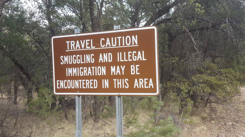
I am a brave one in terms of adventure but this brought cold, penetrating shock. I was not worried about immigrants. I would gladly give them my food and water. But Smugglers? WTF? I drove up a steep, narrow canyon, by myself in a tiny car that could pop a tire or two at any time into a smuggler network. I began to understand the female forest service and national monument staff’s hesitation to send me there. So why didn’t they just come out and tell me? Why didn’t they say, “This is an area with possible smuggler activity? I wouldn’t go up there, and you shouldn’t either.” Clearly, I presented myself as a single female traveler. We usually stick together and watch out for each other.
I drove in haste back down the canyon. I tried to excuse their affront to my safety on public lands. Maybe it is no longer an active smuggling area. Maybe they caught the people. On and on. I drove a different loop back to I-10, going through Sunsites, AZ. I saw a sign to Cochise Stronghold (a great birding area) and almost turned in but I was too rattled to do anything but drive home. Around 6 PM I stopped for a Subway sandwich with extra meat in San Simon, AZ. Tango wolfed down the bread and we shared the warm meat with melted cheese. After a short walk around the area we returned to the car and, on my phone, I googled a life-changing combination of words: Drug smuggling, Chiricahua Mountains.
In that search, I found the facts behind the red flags. The Chiricahuas are an important route for drug smugglers from Mexico. They tend to follow the route used by the Apaches who once roamed the area. They move freely on both the east and west sides of the mountains outside the Monument. This includes both private land and the Coronado National Forest land, including Cave Creek Canyon, where I backpacked as a young woman. One article even mentioned a smuggler in Turkey Creek, where I had been! According to one online source, the area is full of drug scouts and, if they were there yesterday, I am certain they spotted my dust trail as I climbed slowly into the hills. Ranchers and residents in the area have been terrorized by both illegals and smugglers for a long time. One female ranger inside Chiricahua National Monument was brutally attacked but survived, one nearby rancher shot and killed.
As I read more, I learned that public lands all over the borderlands of Southeast Arizona are overrun. Smugglers like the nearby Dragoon Mountains too, which includes Cochise Stronghold where I almost stopped on the way home. All of my favorite hiking spots as a young woman are now smuggler haunts, including Ramsey Canyon and Madera Canyon, both a bit further west. Oh, my! And those ladies — public employees — couldn’t tell me that. They hemmed and hawed but never said what they needed to: don’t go into the mountain canyons after dark and never go alone. It is too dangerous. There! How hard was that? Simple, possibly life-saving words I should have heard from someone.
In the safety of my own bed that night, I trembled a bit and hugged Tango. I realized that many people would say that I put myself in harm’s way. I should have known. In the winter I live 140 miles east of the Chiricahua Mountains, near Deming, NM. I camp in this whole area as well, my new favorites being the Gila National Forest and New Mexico State Parks. In my defense, I would explain that I was here 2 months last year and 5 months this year. I am a Southwest newbie, despite having lived in Tucson from 1972-1983 . Of course, I know of the border issues, but Border Patrol is actively and visibly present here. All the time, along the roads and back down the dirt roads. At Pancho Villa State Park, a few miles north of the border, I see helicopters circle overhead when I stay there. I pass through checkpoints when I drive anywhere in the region. I read with delight about drug seizures and hear stories about how much safer this border area is now. So, it is impossible for me to imagine that drug smugglers run free on our public lands a few hours down the road, especially on well-known trails used by the Apaches in another century. I never saw any Border Patrol that day. Nothing. And no warnings until I was in the dangerous terrain, and then, only a small sign.
I keep going back to the three women I spoke with that day. They knew I was heading into a dangerous area. The didn’t tell me. Are they barred from warning the public? Have they tried before and received a rebuke? Do they all assume that everyone who arrives on public lands in border country is already well-informed of the danger? Then, I go back to the preposterous notion that thugs control public lands. Supposedly they are hard to find, but I know, from other online research, that Border Patrol has advanced technology that has enabled them to start winning the battle They are flush with money and personnel. Are Forest Service and other officials bribed? Again, what is really happening on our public lands? On Monday, I will call both the Chiricahua National Monument and the Cochise National Forest phone numbers. I plan to ask basic questions as if I have never been there before: Is there illegal activity in the area? Drug runners? Is it safe for a single woman to camp in the backcountry? I heard a woman ranger nearly died at the hands of a drug runner. I will update my blog when I have that information. This should be interesting.
In the meantime, my thoughts turn back to my upcoming summer trip to Alaska, I did not get a chance to try out my new tent and screen house while in the Chiricahuas, but the Chiricahua outing taught me something that could make my time on Alaska National Forest Land safer. Follow up on anything that seems odd, ask tons of questions. Visit each ranger station and ask them, as well as campground staff that may be present, every possible question: Any bear activity in the area? Any violence? How often is the campground patrolled? Hazards in the area? Quality of the roads? Would you camp there? Would you feel safe having your grandma in the area? When I encounter half-answers and evasive remarks, I will dig in deeper: It seems like you don’t want me to know about something. I hate to turn Rangers into suspects, but I learned that my safety is not necessarily their prime concern. I needed to discover that yesterday more than I needed to learn how to set up the new tent.

